
How best can we transform our cities and towns with 21st century design ideals that put community and lifestyle first and cars second? Block, Street & Building put that question to city planners via the Arkansas Times Blog and the Arkansas Municipal League, initiating a competition of ideas to create walkable, livable spaces where commercial and residential needs co-exist, and dozens responded with their ideas.
From those, 10 projects were named the best by a jury made up of members of the Arkansas, Oklahoma and Missouri chapters of the American Planning Association. (The contestants were kept anonymous during the judging phase.)
Entries were judged on several criteria, including the quality of the project description; how the projects related to their surroundings; walkability; how the projects were scaled and landscaped to attract the public; and how feasible it would be to bring the projects to fruition.
The winners will be featured in a session of the Arkansas Municipal League’s 89th Annual Convention, June 14-16.
The 10 projects follow.

2nd Street Promenade Argenta Arts District
Connecting the river to downtown.
The 200 Broadway Street address is on one of four blocks that border the north side of the Second Street Promenade between Simmons Bank Arena and Poplar Street in North Little Rock. The promenade is the primary east-west pedestrian-friendly walkway between the arena and Dickey-Stephens Park and passing the newly renovated One Riverfront Place building. The overall vision is to create a pedestrian-friendly corridor by framing out the existing two-block part of the promenade with buildings from the arena to Main Street and Rock Region Metro’s streetcar stop. Working with Rock Region Metro, the city plans to extend the trail from the Junction Bridge at Washington Street to the intersection of Broadway and Magnolia streets that would intersect at the beginning of the promenade at the entrance of the Arkansas Sports Hall of Fame, adding the missing north-south pedestrian-friendly access to linking the Junction Bridge to Argenta’s historic Main Street.
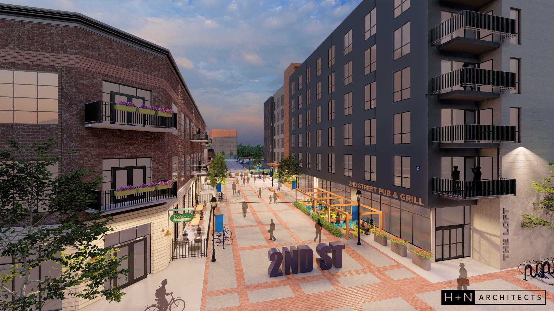
The development currently in the planning stages at 200 Broadway Street would include a building on the corner of Poplar Street and the promenade, and one adjacent to the trail and the promenade with a hotel connected to it and bordering the trail extension to Broadway Street. The city of North Little Rock has plans to build a conference center on the south side of the promenade between Poplar Street and Main Street. Future developments could be added to the remaining two blocks.
Greg Nabholz, CEO of Nabholz Properties in Conway | Placemaking, Economic Development Consultant

Osceola Pocket Park
Connecting history and community.
The community of Osceola has commemorated its musical and agricultural heritage through the installation of 36 historic markers as part of the Delta’s Cotton Highway. Six of these markers are located on an empty lot in downtown Osceola at the corner of Poplar and Hale streets. Except for a stage and six of the markers, the space is insignificant and underutilized. Main Street Osceola came together to work with landscape architect Brantley Snipes to design an innovative space to connect its history to its present-day community. The design strategically utilizes the Cotton Highway winding river insignia with hardscape elements to connect the stage to the town square. All hardscape elements will be flush, allowing both flexibility in use of space and accessibility by people of all ages and abilities. From downtown concerts to festivals and all events in between, this space will be accommodating and accessible to pedestrians from all neighborhoods in the community.

Bright shade sails will be added to provide comfort for visitors to the space. The sails will be eye-catching, drawing the attention of both pedestrian and vehicular traffic. Instead of one large shade sail, three smaller ones will be installed to create different gathering spaces within the overall context of the site. The footprint of the insignia river triangle provides adequate hardscape, visual interest and reduced construction costs. New landscaping will be installed in order to separate vehicular traffic areas from the new plaza, protect pedestrians and complement the newly designed space. What was once a vacant, pass-through lot will now become a living intersection of history and community.
Brantley Snipes of Brantley Snipes Landscape & Design, Inc in collaboration with architect Ryan Biles of Kudzu Collective.

The ‘Fuzzy Urbanism’ of Markham Square Housing District
The urban square and the forested hillocks.
Housing is an issue of territory as much as it is of building. The Markham Square Housing District, a downtown regeneration proposal for a vacated industrial metal yard in Conway, is a housing approach beginning with the concept of a living transect that connects the square and shared streets to building frontage, housing court and patio, and interior space — all articulated as a series of rooms. This invokes Christopher Alexander’s pattern language No. 122 to design the front edge of the building as a place. Building frontages should create “scalloped edges” or a fuzzy urbanism. Thick building edges accommodate a variety of social activities through urban building frontage (porches, balconies, decks, stoops and terraces), liminal spaces not specific to one housing type. The goal is to incentivize living downtown by structuring a walkable mixed-income neighborhood for a downtown that lacks a tradition of multifamily housing.
Two primary place types cluster housing around distinct urban landscapes for ecological and social repair. An extroverted residential square with shared streets articulated as a rain terrain features a neighborhood art park in a “wilded” landscape supporting ecological-based stormwater management (the park has been built). Shared streets are designed to be destinations rather than traffic arteries. They compel motorists to behave socially. Shared streets are designed to keep traffic speeds under 17 miles per hour, the threshold up to which pedestrians and motorists can maintain eye contact and socially negotiate their shared use of the right-of-way. While the square foregrounds stormwater treatment landscapes, a new forested hillock on a remediated brownfield provides a more discrete neighborhood node for stormwater treatment landscapes on the garden-side of multifamily units. The hillock adds a piece of suburbia as the backyard becomes a unique landscape opposite the home’s urban front.
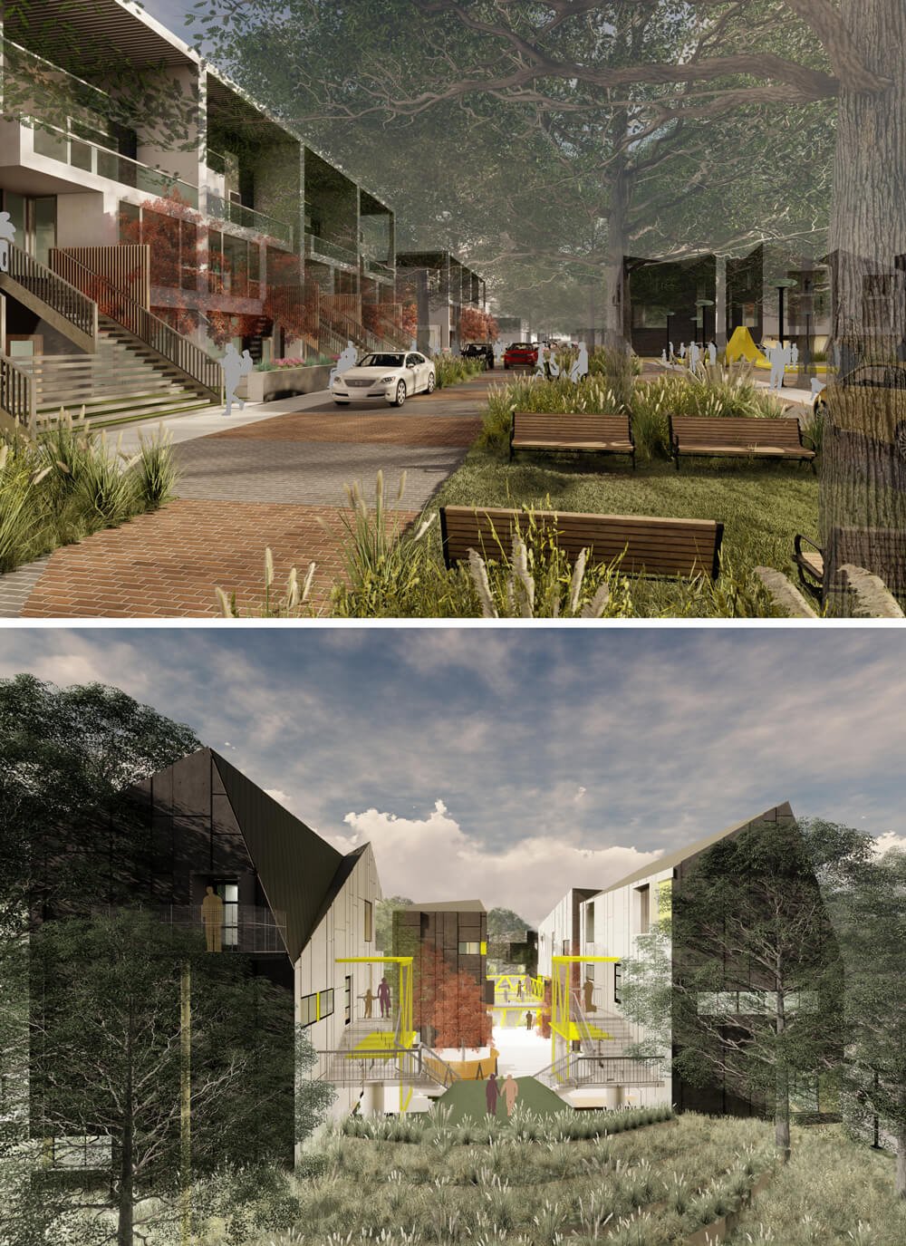
The project recalls affordable walk-up residential typologies — rowhouses, bungalows, triplexes, courtyard housing and townhouses — that have not been built since the hegemony of suburban policy in the 1950s. Now, these affordable types are key to revitalizing mid-sized downtowns without the population dislocations accompanying gentrification. Housing types ranging between 900 and 2,100 square feet accommodate a mixed-income neighborhood, particularly for workforce populations lacking transportation options. Housing typologies pair economy of means (targeted construction costs between $150-$200/sf) with good town form and amenities that deliver an optimal living transect.
University of Arkansas Community Design Center, an outreach center of the Fay Jones School of Architecture and Design.
This project was made possible by funding from the National Endowment for the Arts “Art Works” Program.

Scan for a list of participants on this project.

The Urban Corner
Filling in the gap.
So many undeveloped corners in downtown Little Rock’s core are reminiscent of a missing tooth in the urban smile of our city. Here is a cost-effective implant … so to speak!
This mixed-use design is intended for infills in the edges of the urban fabric as it transitions into residential neighborhoods or smaller-scale commercial. It occupies a quarter-block-size site. This is a type prevalent in downtown, though many are used as surface parking lots. The modest two-story walk-up, with commercial tenant space on the ground floor and six apartments on the second floor, plays well with the residential neighbors while at the same time provides an active street frontage. The building addresses the corner enforcing the urban fabric and scale, specific to downtown Little Rock. The complex could be mirrored and complete a half-block or even full block, with parking and deliveries behind the building, and in some cases accessible by alleyway.

The efficient layout of the building packs a lot of use into a small footprint, resulting in a dense, vibrant development that can benefit the experience of the downtown Little Rock streetscape. The ground floor retail level is flexible for two or three tenants and sized to better fit the scale needs of today’s more modest local eateries and shops. The six upper-floor residential “walk-ups” are geared toward a market demand for budget-friendly housing solutions for the younger rental market with an assortment of one-bedroom units with nice amenities like balconies that look out over the street, open living space and in-unit washers and dryers. All of this fits within 12,500 square feet of construction.
The scale is such that the construction type has flexibility, the financial risk is scalable and the style of exterior skin can be customized to the immediate context. The Urban Corner is a great idea to start to build back a more dense urban fabric and a more vibrant smile in downtown Little Rock!
David Sargent, AIA, LEED AP, principal/CEO, WER Architects
Benjamin Gregory, AIA, principal/project architect, WER Architects

Big Rock Quarry Park
Reconnecting North Little Rock’s parks.
Big Rock was an operating quarry as early as 1849, mining predominantly sandstone and shale rock formations. The quarry was in operation for over a century surrounded by bluffs up to 200 feet in height; but now, the 64-acre site located along the Arkansas River sits largely vacant.
The former quarry rests between many important and notable neighbors, including the University of Arkansas Pulaski Tech and the Eugene J. Towbin Veterans Administration Healthcare Center at historic Fort Roots. The rim of the canyon is ringed by Emerald Park, and Burns Park is just north of the site. Nearby communities include Baring Cross, Rockwater and the Esplanade.

The Big Rock Quarry Park project proposes to create a new active lifestyle park that acts as a community hub and crossroad between all these important places. The vision for the park includes a new pavilion along the River Trail with retail and bathroom facilities and a large central green that could host events and space for families to romp and play. An outdoor amphitheater nestled against the bluff would create a world-class performance space. At the center of the park would be a large playground incorporating traditional, inclusive and adventure play components. The upper bowl of the park would be left as natural as possible while expanding the current mountain biking efforts to create a competition quality venue capable of hosting regional tournaments and festivals.
James Meyer, architect, Taggart Architects
Brie Gregory, architectural associate, Taggart Architects
Brett Budolfson, landscape architect, MCE Inc.
Ruxin Tao, project designer, MCE Inc.
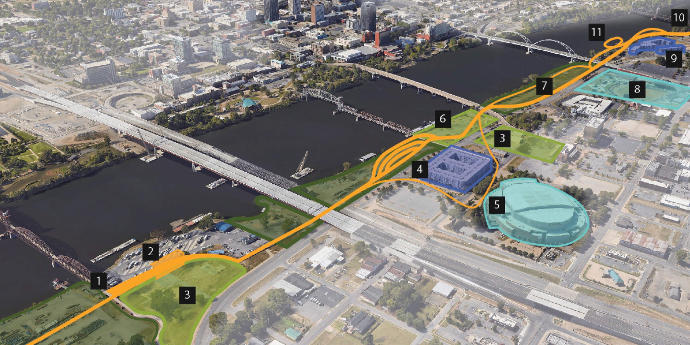
Riverfront Boardwalk
Connecting downtown North Little Rock to the River Trail.
Since 2006, Central Arkansans have enjoyed the 15.6-mile Arkansas River Trail loop that connects the cities of Little Rock and North Little Rock. Along its length, users enjoy Little Rock’s Riverfront Park, First Security Amphitheater, the Clinton Presidential Library Center, multiple pedestrian bridges, four parks and the Big Dam Bridge. Unfortunately, the downtown North Little Rock section of the trail is often jammed up against the seawall, or strung through the middle of parking lots, or jiggered around awkward circulation for the previously mentioned pedestrian bridges. The primary issue is the seawall, which runs along downtown to protect the low-lying areas from flood waters. It is necessary, but unsightly.

The Riverfront Boardwalk project proposes to solve this problem by creating an elevated multiuse path that strings along the riverfront, reconnecting the urban fabric to the river and augmenting both existing and new programming along the riverbank. The boardwalk straddles the seawall spanning from the Clinton Presidential Pedestrian Park Bridge to north of the Broadway Bridge as a series of weaving and undulating ribbons that provide amenities and access to the River Trail.
The new boardwalk would extend from the Clinton pedestrian bridge (1), and provide connections to the downtown RV park (2), the Metropolitan Apartments (4), Simmons Bank Arena (5), the Arkansas Inland Maritime Museum (6), Dickey-Stephens Park (8), the Broadway Bridge, and the Vue Apartments, before it merges into the Arkansas River Trail again (10). The boardwalk would enable multiple future economic development projects (3) and provide improved access for festival events like the Pulaski County Fair (7).
James Meyer, architect, Taggart Architects
Brie Gregory, architectural associate, Taggart Architects

ROCK|21
Small-scale urban infill in the Pettaway neighborhood.
Building off the success of the neighboring Pettaway Square development, the proposed Rock|21 project brings the principles of Lean Urbanism to the intersection of Rock and 21st streets. The project includes leasable spaces sized to keep tenant costs attainable for small and new local businesses while still unlocking the multiplier effect of density.
Rock and 21st streets are fronted by three-story mixed-use buildings populated by local restaurants, retail and commercial office space. Residential townhouses wrap around the commercial buildings, creating pedestrian courtyards. In the center of the courtyards is a mixed-use building that incorporates a first-floor covered patio with outdoor seating and a community event space above.
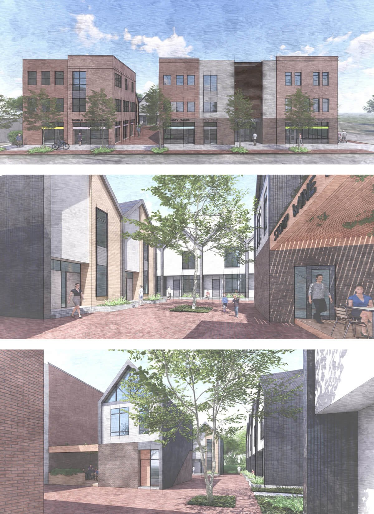
Parking for the development is nestled behind the townhouses and screened from Rock Street by landscaping and a micro commercial building facing the street.
Projects like Pettaway Square and Rock|21 are critical for urban neighborhoods like Pettaway to anchor themselves and provide all the basic services and amenities required for modern lifestyles in affordable and accessible ways.
James Meyer, architect, Taggart Architects
Brie Gregory, architectural associate, Taggart Architects
Mike Orndorff, developer, Pettaway Square
Adam Fogelman, VP, Common Ground Development

Markham Road Diet
Bringing a pedestrian scale back to Stifft Station.
The Stifft Station commercial district, in what is one of the most progressive and dense residential neighborhoods in Little Rock, has intact commercial bones but is extremely underutilized. The Stifft Station intersection was developed in the early 1900s as the first stop on the westward section of the Little Rock trolley line. The existing architecture is of period and has its own subtle yet unique mix of styles. Many of the major New Urbanism principles in the neighborhood are already intact; the goal of this project is to apply the missing principles and vastly improve the well-being of an already great community.
The Markham Road Diet proposal converts a high-speed, relatively low-volume four-lane road to a two-lane road with turning lanes and significant pedestrian improvements. The four-lane is a barrier between two high-density residential neighborhoods: Hillcrest on the north and Stifft Station on the south, both of which have sidewalks and low-speed streets and are walkable. Markham is being redesigned as a high-quality pedestrian connector between the Stifft Station Commercial District and the University of Arkansas for Medical Sciences District.

A bit more design focus has been on the intersection and a couple of blocks at Markham and Kavanaugh at the commercial hub of Stifft Station, a retail corridor that aside from a restaurant or two is somewhat vacant due to fast traffic and insufficient sidewalks, which makes for nearly zero foot traffic and makes it hard for any type of business or retail to thrive. Widening the sidewalk to 12 feet and providing traffic calming as well as a landscape buffer will create a strong pedestrian scale, storefront access and destination gathering areas at the commercial core. This area will also include Little Rock’s first “bike through” intersection.
The engineering and construction drawings are nearly 100% complete and ready to give Stifft Station a stronger community presence, a higher walkscore and a higher quality of life.
Dan Beranek, professional engineer, LR office president
Maneesh Krishnan, professional engineer, project manager (formerly with MCE)
Jeremy Waits, engineering intern, project designer
Austin Petty, engineering intern, project designer
Brett Budolfson, landscape architect
Edwin Hankins IV, landscape architect
Zhijiao Li, landscape architect
Peter Stanley, landscape architect intern (formerly with MCE)
Ruxin Tao, landscape architect intern

University District
Fixing the most dangerous street in Little Rock.
Fun fact that many commuters do not realize: South University Avenue along the UA Little Rock campus has a speed limit of 25 mph. Unfortunately, the street design in this area features a channelized divider, wide lanes and broad sight lines just like arterial highways. Perhaps that is why drivers today average speeds of nearly 45 mph in this area. Students, faculty and staff can be seen dodging traffic daily as they try to navigate between campus and the adjacent businesses and parking lots. Over the years this has led to many accidents and even fatalities.
The University District project proposes to “right-size” the road and redevelop the adjacent shopping centers to be people-centric in lieu of car-dominated. The street would be reduced to four traffic lanes (from six) while adding bike lanes and improved sidewalks on both sides of the street. The center divide would also be widened to allow for vertical landscaping, which would also help control speeds.

Access across University Avenue would be augmented by two gateway intersections at 28th Street and Asher Avenue that would use raised pedestrian tables at crosswalks and intersections to control vehicle speeds and behavior. Between the gateways would be four pedestrian crossings, including a large pedestrian bridge connecting campus directly to a proposed bus station on the west side of University Avenue.
Once University Avenue becomes safer and easier to navigate, economic development will follow. The shopping centers on the west side of University Avenue will be ripe for conversion into mixed-use developments that can engage with the surrounding neighborhood and UA Little Rock.
Sarah Bennings, Brandon Bibby, Heather Davis, Chris East, Mason Ellis, Kyle Marsh, James Meyer, Joe Stanely, Caleb Tyson, Glen Woodruff, Chad Young, Nikki Crane, Brie Gregory, Wes Mitchell, Min Wui. All project volunteers with StudioMain.

Little Rock Art Trail
Connecting AMFA to the River Market District.
The Little Rock Art Trail connects the Arkansas Museum of Fine Arts with Riverfront Park and the River Market District. It includes a new entrance design for Riverfront Park and creates Whitewater Park at Interstate 30, Cherry Blossom Promenade along Cumberland and Sherman streets and mixed-use development opportunities along Cumberland.
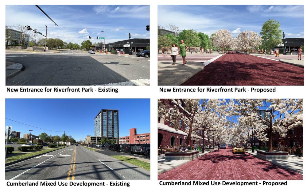
Cumberland is reduced to two lanes for cars, with wide sidewalks allowing for outdoor dining, art installations, landscaping and other features from La Harpe Boulevard to Seventh Street, where the trail turns east to Sherman Street, then south to Ninth Street. La Harpe is reduced to two lanes from State to Markham streets, with parallel parking on the north side. The wall along La Harpe is removed, opening it up to Riverfront Park. The new Riverfront Park entry creates a pedestrian plaza on the east side of the Little Rock Regional Chamber of Commerce building.
Ed Levy, AIA, LEED AP, OSHA 10, principal, architect, Cromwell Architects Engineers